A DESERT SPRINGTIME ADVENTURE:
CORKSCREW PEAK (5,804'), PAHRUMP POINT (5,740'), MOAPA PEAK (6,471'),
POTOSI MOUNTAIN (8,515'), NEW YORK MOUNTAIN (7,532'), AND CLARK
MOUNTAIN (7,907'), WITH SOME OTHER DESERT TRAVELS
April 2-12, 1993
I had
been game for some desert peak climbing for a long time. I tried
to schedule a spring break desert activity in the local chapter
schedule for years. No takers!
Finally, my peak companion Rex had retired,
and was now available for this trip. He knew that he would get
expert guidance, and highly economic rates on lodging and transportation.
My thought later was that he was "led and fed, driven and
given." His only shared expense was to contribute to the
gas costs, a drive of 1,850 miles, all at about 35 miles per gallon.
Since he would never return the favor, I asked the local chapter
rate of 5 cents a mile.
We left on April 2nd, to motor down past
the still snowy High Sierra, along
U.S. 395. We took the turnoff to Death Valley, then on Highway
190. I took a photo of Panamint
Butte, a peak that I still need.
Camping at Stovepipe Wells, I awoke early
to discern that it would be a warm day. Rex says he is a morning
person, so he didn't object much to our leaving early to the parking
spot for Corkscrew Peak.
I had already done this peak, but since he needed it, we would
do it.
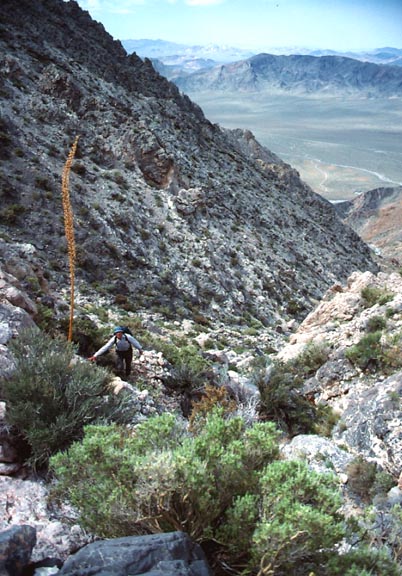
I led the way, knowing where there was
a use trail. We approached the massif, and I took a different
way, presumably the way the DPS uses as per their Guide. It wasn't
as good. We had to climb a steep gully, with loose, rubbly rock.
It led to a short class 3 section, where I waited for him to make
the move. For awhile, I didn't think he would make it.
We reached the route along the main ridge,
and climbed slowly to the top. There is a trick to the route,
which I knew from my ascent in 1983. I tried to photo-document
this route a little better. It was my general plan to photograph
the critical points on every peak I was to climb, for a photo
guide to the peaks. The idea was to arrow in the route as climbers
would see it, all using a computer. By a picture, you would head
for the arrow, and then, have another picture with another arrow
on where to head, then. I feel that present climbers guides are
much too vague, and often of little value. As Confucius said,
"A picture is worth a thousand words."
We reached the top after a cooling breeze
allowed us to. I was pleased at our first peak ascent for this
trip. I looked at the register.
We descended quickly along the regular route that I now use.
Back to the car, we motored over to Furnace
Creek, and toured about, viewing the historic sites, and for me,
photographing the spring bloom. Driving on south and then east
on Highway 190, we came to
a view of Pyramid Peak,
which we had climbed in 1986. The peak doesn't look anything like
we saw it that time. Mountains have many sides, and one cannot
assume from one view that it looks about the same from another
view!
On a short stop, I saw that I had a leak
in one tire. I changed the tire, but since it was now a weekend,
and we were so far from towns, I couldn't get it serviced and
fixed. We drove to Shoshone, CA, where we dined and camped nearby.
 Our
next climb was Pahrump Point. We drove northeast on Highway 178
to the parking near a dirt 4WD road. We took this road two miles
to the regular 4WD parking, then followed the main
gully up the peak. It was very rocky and rough. Only a few
hikers would have the determination and verve to do this. Rex
had done this peak before, so I thought he would be of some help
on the route. He didn't remember much. Luckily, I had my copy
of the guide, so found the way. The first person to find this
was very smart--a real peak pioneer!
Our
next climb was Pahrump Point. We drove northeast on Highway 178
to the parking near a dirt 4WD road. We took this road two miles
to the regular 4WD parking, then followed the main
gully up the peak. It was very rocky and rough. Only a few
hikers would have the determination and verve to do this. Rex
had done this peak before, so I thought he would be of some help
on the route. He didn't remember much. Luckily, I had my copy
of the guide, so found the way. The first person to find this
was very smart--a real peak pioneer!
We reached the main ridge, and got more
views. The top was a short way to the left, or north. There was
the usual haze in the air, so my 360 degree panoramas will be
of little value, except to record the view.
I would know if a photo was taken at the true summit, since I
will have my own record. Once, one person at work had produced
a purported summit photo, which I knew just from memory that it
was not! I sadly told her that this was not taken from the summit
that her friends claimed!
We had pleasant weather, and enjoyed looking
through the register. Indeed, some of the local chapter desert
climbing group had signed in on this one.
We downclimbed and found our route, thanks
to my good memory and some ducks. The climb is by no means finished
upon reaching the summit! We had lots of time, and I looked forward
to another climb the next day. Some purple/pink
flowers were nice photos, with the sun more bright now, after
the morning's clouds.
Back to my car, the tire was again flat,
after I had pumped it up at a gas station in Shoshone. I once
again changed it, and we drove back to Shoshone to enjoy the end
of the local arts and crafts fair. We camped nearby, and Monday,
drove to Pahrump to get the tire fixed. A small metal burr was
shown to me to have caused the leak.
We motored out to U.S. 95, where we planned
to climb Mt. Stirling. Following the guide directions, we came
to a highly indistinct dirt
road with a gate. "Wow," I said. "These DPS
climbers take on some bad roads!" There was no way with my
passenger wagon, and also with plenty of snow on the peak.
We headed on south to Las Vegas.
Getting to this great metropolis, I had to
make some alternate plans. We found there was a museum, so we
looked for it. Finding it by signs, we took a look at the Las
Vegas History Museum. There were interesting
exhibits. Mainly dwelling on recent history, I read that the
1950's Las Vegas was noted for its diversity, despite the segregation
laws that governed much of the rest of the nation at that time.
We drove on into the old downtown section,
or as it is known, "Glitter
Gulch." We checked on hotel rates. This was midweek,
so the rooms would be cheaper. We got a reasonable room rate at
the Union Plaza Hotel, right on the end of Fremont Street. The
weather had turned stormy this day. Checking in under a roof,
today, made good sense. Rex had set a condition of less camping
on this trip, which I agreed to, knowing the great lodging deals
advertised in the L.A. Times.
Tuesday, we woke up early, and had a $1.99
rib eye steak and eggs breakfast. This is a lure for gamblers,
of course, but at 5 a.m. in the morning, we were the only ones,
almost, taking this fine meal.
We drove east on Interstate 15 toward Arizona
and Utah. I had my sights on Moapa Peak. Another local chapter
group had failed to climb this peak, due to weather, but it interested
me in that there were two class 3 sections to get to the top.
Reaching the proper freeway exit, we looked
at the peak. It can be seen many miles away, bringing some apprehension
as it looks very steep and high. I took a deep breath, and we
got back into my car, and I drove toward it. There were rough
parts on the dirt road, and the guide wasn't real accurate. Able
to drive to within three miles of the roadhead, I had to stop
and park before a washed-out section.
Getting our gear together, we started hiking
on this dirt road by about 10 a.m. There are some dips in this
road, and Rex announced that by his altimeter, we climbed some
300 feet just getting to the regular parking.
We wondered if we should continue. One
tactic is to go by the clock, setting a turn-back time to return
by dark. I thought we could do it, and it takes a game heart to
try such things. Walking through Jacks Pocket, a name on the map
on a flatter area, we began the climb upward. Clouds and beautiful
light shone on the desert hills. We came to the first class
3 section. There were lots of ducks. I found a way, and Rex followed.
We came to features that the guide described.
We were on route. As we came to a long traverse, I spotted a bighorn
sheep, and then its lamb. They circled us warily, but seemed curious,
at first. We stayed motionless. I began to take pictures, then
came up with one good one. They scurried away, and we waited to
not panic it. After it disappeared, it had shown the route to
the summit. A dirt trail along the cliffs went horizontally, and
then up to the main summit ridge. This animal trail greatly facilitated
our hiking time. I knew from others' accounts that many bighorns
lived up here.
 By
good navigation, we came to the class 3 summit knife-edge ridge.
Remembering from one description, we looked for an easier way
on the right, then found there was none. I went back to the northeast
end of the knife-edge, found the short, rocky route up to it,
and then saw the rest of the route. I had some queasy feeling
that it might be really exposed,
but it was a piece of cake. Rex found it easy, too.
By
good navigation, we came to the class 3 summit knife-edge ridge.
Remembering from one description, we looked for an easier way
on the right, then found there was none. I went back to the northeast
end of the knife-edge, found the short, rocky route up to it,
and then saw the rest of the route. I had some queasy feeling
that it might be really exposed,
but it was a piece of cake. Rex found it easy, too.
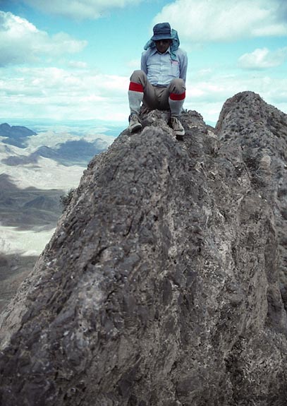
Then, after some five hours of climbing,
we reached the register and the top. The views
were accented by clouds. The hikers guide calls this a climbers'
favorite. Most of the entries were by the DPS. I had a fantasy
that Vegas showgirls used this hike as exercise. Not to be!
We had heard loud booms, which we thought
at first, were thunder. We surmised that it was ordinance exploding
at a military testing site far away to the west. We were just
getting involved in Bosnia.
On our downclimb, I took the wrong big
ledge back along below the main ridge. I knew something may have
been wrong, but we continued. I realized my mistake, but thought
we could find a way through. Losing precious elevation, we came
to a relatively short drop-off. I figured it was too dangerous
to try, so we turned back and added perhaps another 500 feet gain
to our day.
I found where we had gone wrong, and hurried
along, trying to race the sunset. We came back to the lower class
3 section, and had a delay finding the best place to downclimb.
I did a spot, but Rex couldn't make it. I waited a few minutes,
then suggested trying another spot. He did that.
Finally, we came back to flatter ground,
and were soon on the dirt road. I had a headlamp, so all we had
to do was walk the three or so miles on dirt road to the wagon,
and then drive out back to the Interstate. We were back to the
car at 8 p.m., about past dusk.
Motoring out on the rough road wasn't easy
either. Rex yelled as I hit a rock while motoring back up a steep
hill. Sometimes, a driver has to give it the gun, lest the car
stall. A bit of momentum helps, too, on a steep section.
We got back to the Interstate, zoomed southwest
to a small town where we got dinner, and then camped in the desert
near the road to the Valley of Fire State Park.
Next
BACK TO PETE'S THOUSAND
PEAKS HOME PAGE